- Archaeological News
-
 Image Credit: Holzer et al., npj Heritage Science (2026)
Flash Lidar Technology Opens New Possibilities for Underwater Archaeology
Researchers have demonstrated the successful use of flash lidar technology for high-resolution mapping of submerged archaeological sites, offering a faster and more detailed alternative to many traditional underwater survey methods. The study tested the system at three European heritage sites in Switzerland, Germany, and Greece, where it produced dense three-dimensional models of underwater structures and landscapes.
The project focused on a portable time-of-flight flash lidar system known as (Airswim), designed for deployment from unmanned surface vehicles. Unlike conventional sonar systems, which efficiently map large underwater areas but often lack fine detail, the lidar system captures centimetre-scale structural information while operating at survey speeds comparable to acoustic methods.
Researchers tested the technology at the submerged prehistoric pile-dwelling site of Les Argilliez in Switzerland, the remains of medieval bridge structures near Roseninsel in Germany, and the partially submerged Roman villa at Epidaurus in Greece. The system successfully recorded wooden piles, architectural remains, foundations, and subtle lakebed features under varying environmental conditions.
According to the study, flash lidar combines advantages traditionally divided between acoustic and optical survey methods. Multi-beam sonar systems can rapidly map extensive areas but often struggle to capture small details, while underwater photogrammetry produces highly detailed models but requires long acquisition times, favourable water clarity, and extensive post-processing. The lidar system was able to generate dense point clouds directly from laser measurements with significantly reduced processing complexity.
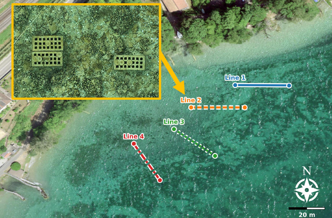
At the Epidaurus site, researchers collected nearly 1.84 billion points across an area measuring approximately 52 by 46 metres. The resulting models documented walls, foundations, and circular structural features of the submerged Roman villa with high completeness and centimetre-level precision.
The study also demonstrated that the system can operate effectively under changing light conditions because the lidar relies on laser pulses rather than ambient illumination. Researchers noted that the technology remains effective even in shallow waters where photogrammetric surveys can be complicated by reflections and refraction at the water surface.
While some calibration and synchronization limitations were identified during the experiments, the researchers concluded that flash lidar offers a promising new tool for the rapid documentation and monitoring of underwater cultural heritage. They also suggest that the technology could eventually be integrated with underwater photogrammetry to create detailed textured three-dimensional reconstructions of submerged archaeological sites.
Published on: 12-05-2026
Edited by: Abdulmnam Samakie
Source: npj Heritage Science