- Archaeological News
-
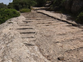 Image Credit: Davidbena, CC BY-SA 4.0
Digital Atlas Redefines Ancient Roman Roads
A new digital atlas has revealed that the Roman road network extended nearly 50% farther than previously thought—covering about 186,000 miles (300,000 km) across the empire, from Spain to Syria.
The study, published in Scientific Data, updates a 25-year-old map using satellite imagery, aerial photos, and WWII archives. Over five years, archaeologists traced subtle landscape clues—like soil changes and ancient engineering marks—to uncover forgotten routes.
“This was like connecting dots across a continent,” said Tom Brughmans of Aarhus University, the study’s co-author. The map now includes secondary roads linking villas, farms, and trade centers, not just the main imperial highways.
The findings expand understanding of Roman infrastructure, especially in North Africa, France, and Greece. According to Adam Pažout of the Autonomous University of Barcelona, the road system shaped trade, religion, and even the spread of diseases across ancient Europe.
Roman road-building skills—bridges, tunnels, and drainage systems—still influence modern transport routes around the Mediterranean today.
Published on: 07-11-2025
Edited by: Abdulmnam Samakie
Source: The Independent
-
More News Possible Ancient Dams Near the Red Pyramid May Reveal New Hydraulic Engineering at Dahshur (20-07-2026) Ancient Bones from Dahshur Reveal New Details About Egypt’s Royal Family (19-07-2026) Population Growth May Have Sparked Cultural Complexity in Paleolithic Japan (18-07-2026) Science Reconstructs the Last Months of Inca Child Sacrifices (17-07-2026) Royal Bronze Bowls Reveal How Urartian Kings Used Writing and Craft to Express Power (16-07-2026) Medieval Graves Reveal the Mixed Origins of Vilnius’s First Christians (15-07-2026) Curaçao’s Cultural Landscapes Reveal 5700 Years of Human–Environment Interaction (14-07-2026) 3D Thermography Offers a Safer Way to Detect Hidden Damage in Lacquerware (13-07-2026) Early Lead Smelting in Iberia Reveals a Short-Lived Prehistoric Innovation (12-07-2026) Ancient DNA Reveals How Children Were Buried in Early Christian Sweden (11-07-2026) What Happened at Brading Roman Villa? (10-07-2026) Ancient Salt-Production Site Near Rome Gains a More Precise Date (09-07-2026) Researchers Challenge the Classification of Stone Tools from Cueva Millán (08-07-2026) Archaeology Reveals a Roman Settlement Built for a Forcibly Relocated Community (07-07-2026) Virtual and Augmented Reality Open New Paths for Preserving the Great Wall (06-07-2026) New Evidence Challenges Ideas About the Hunting Skills of Homo floresiensis (05-07-2026) Roman Sling Bullets Reveal an Attack on Ambleside Fort (05-07-2026) Ancient DNA Reveals Dynastic Rule Among Iron Age Steppe Elites (04-07-2026) New Dates Rewrite the Early Human Story of Central Asia (03-07-2026) Ancient Communities Responded to Illness Through Care, Belief, and Social Networks (02-07-2026) Ancient Stelae Reveal a Crossroads of Memory and Exchange in Spain (01-07-2026) X-rays Help Trace Roman Pottery Found on Britain’s Northern Frontier (30-06-2026) Medieval Pigs Show How Communities Managed Changing Landscapes (29-06-2026) Digital Technologies Reshapes the Protection of Intangible Cultural Heritage (28-06-2026) Skeletons Rewrite the Story of Medieval Nubia (27-06-2026) Were Roman Forts in South-eastern Britain Overstated? (26-06-2026) New Genetic Study Challenges Views of Neanderthal Decline (25-06-2026) Ancient DNA Found on Cave Walls Opens New Window into Prehistoric Human Presence (24-06-2026) New Fossil Analysis Rethinks How Human Body Size Evolved (23-06-2026) Natural Collagen Treatment Could Help Protect Historic Leather Objects (22-06-2026) 12,000-Year-Old Clay Fragments in Turkey Point to Early Pottery Experiments (21-06-2026) Ancient Seeds Reveal How Neolithic Farmers Fed a Growing Community (20-06-2026) Ancient Earthquakes Reshaped an Early Bronze Age Settlement in Western Anatolia (19-06-2026) Ancient Plague Outbreaks Hit Lake Baikal Hunter-Gatherers 5,500 Years Ago (18-06-2026) Hazar Merd Cave Reopens a Key Chapter in Zagros Prehistory (17-06-2026) New Method Reassesses Wealth Inequality in Ancient Societies (16-06-2026) Medieval Gameboard in Morocco Reveals Early North African Gaming (15-06-2026) Ancient Porridge Traditions Reveal Africa’s Culinary Continuity (14-06-2026) Stone Age Burials in Latvia Point to Specialized Work Roles (13-06-2026) Canary Islands Site Reveals Specialized Medieval Marine Processing (12-06-2026) Iron Age Burials in Scotland Reveal Unusual Funerary Practices and Long-Distance Links (11-06-2026) Rare Glazed Ceramics Reveal Iron Age Exchange at Tall Zarʿa in Jordan (10-06-2026) Paleolithic Ornaments Reveal Identity and Mobility in Northern Spain (09-06-2026) New Evidence Pushes Early Fire Use at Wonderwerk Cave Further Back (08-06-2026) Insect Eating Was Rare in Ancient Europe (07-06-2026) Stone Tool Cache in Ohio May Belong to the Early Woodland Adena Culture (06-06-2026) Review Reframes East Africa’s Turkwel Tradition as a Dynamic Cultural Network (05-06-2026) Digital Point Clouds Support Risk Assessment for Historic Stone Bridges (04-06-2026) New Study Reveals the Iceman’s Microbiome Is Still Changing (03-06-2026) Ancient Ditches Reveal Flax Processing in Sardinia and Spain (02-06-2026) AI Tool Helps Recognize and Restore Ancient Tamil Palm-Leaf Manuscripts (01-06-2026) Mongolia’s Xiongnu Cemetery Was Organized More by Status Than Family Ties (31-05-2026) Signs of Respiratory Disease in Copper Age Children in Iberia (30-05-2026) Study Identifies Ancient Cooking Areas in Ecuador’s Upano Valley (29-05-2026) Study Estimates Manganese Used in Ancient Chinchorro Mummification (28-05-2026) Traces of Ancient Anaesthetic Found on Ming Dynasty Surgical Tools (27-05-2026) Neolithic House Size May Not Signal Inequality (26-05-2026) New Ways to Protect Metal Artifacts Inside Ancient Japanese Tumuli (25-05-2026) Ancient DNA Reveals Migration and Family Burial Traditions in Pre-Inca Peru (25-05-2026) Possible Earliest Evidence of Human Cremation Found in Ethiopia (24-05-2026) Mobile GIS Offers New Path for Protecting Local Heritage Sites (23-05-2026) Tudor Coastal Fort to Be Investigated Before Erosion Claims the Site (22-05-2026) Stone Tools Reveal Mobility in the Upper Paleolithic Pyrenees (21-05-2026) Arctic Warming Threatens Historic Whaling Burials in Svalbard (20-05-2026) Excavation Reveals New Mortuary Tradition at Laos’ Plain of Jars (19-05-2026) Roman Medical Care in Colchester Revealed Through New Study (18-05-2026) Roman Mosaics in Spain Made from Recycled Mining Waste, Study Finds (17-05-2026) New Study Reassesses the Early History of the Lacedaemonians in Ancient Laconia (16-05-2026) Medieval Ceramics Reveal Innovation and Exchange in Southern Italy (15-05-2026) New Study Challenges Conventional Timeline for Horse Domestication and Riding (14-05-2026) Ancient Proteins Reveal Genetic Links Between Homo erectus and Denisovans (13-05-2026) Flash Lidar Technology Opens New Possibilities for Underwater Archaeology (12-05-2026) Monumental Burial Tradition Reveals Ancient Pastoral Culture in the Atbai Desert (11-05-2026) Why Jurassic Coast and Isle of Wight Are Fossil Hotspots (10-05-2026) Evidence of Prehistoric Occupation Discovered Above 2000 Meters in the Pyrenees (09-05-2026) Ancient Cuneiform Letters Read Without Opening Their Clay Envelopes (08-05-2026) Neolithic Ditches May Reveal Early Water Management in the Aegean (07-05-2026) Digital Technologies Help Preserve Historic Jungar Temple Complex in China (06-05-2026) Iron Production in Ancient Xinjiang Reveals Frontier Innovation in the Han Era (05-05-2026) Ancient Island in Scotland Reveals Hidden Wooden Foundation (04-05-2026) Dragon Stones Point to Organized Society in Ancient Armenian Highlands (04-05-2026) New Excavations Reveal Urban Development of Ancient Alexandria (03-05-2026) Climate Shifts Shaped Health and Population Patterns in the Ancient Andes (02-05-2026) A Fifth Century Burial Reveals a Changing Economy in the Post Roman World (01-05-2026) Malaria Influenced Human Settlement Patterns for 74000 Years (30-04-2026) DNA Study Reveals How Local Communities Shaped Post Roman Europe (29-04-2026) Nile Dynamics Shaped the Rise of Ancient Nubia (28-04-2026) Man Used Mortar to Shield Himself During Vesuvius Eruption (27-04-2026) AI and Spectral Imaging Improve Identification of Ancient Ruins (26-04-2026) New Evidence of Hadrian Wall Artifacts Found in Spain (25-04-2026) Genomic Study Reveals Complex Origins and Diversity of Indigenous Americans (24-04-2026) Scientific Analysis Confirms Early Chicken Husbandry in Ancient Korea (23-04-2026) Archaeologists Document 124 Shipwrecks in the Bay of Algeciras (22-04-2026) Survey and Excavation Project Brings New Focus to Southern Georgia Archaeology (21-04-2026) New Genetic Evidence Reconstructs Early Neanderthals in Central Eastern Europe (20-04-2026) Roman Necropolis and Rare Iliad Papyrus Discovered at Oxyrhynchus (19-04-2026) Bolivian Mummy Yields Earliest Confirmed Genome of Streptococcus in the Americas (18-04-2026) Qing Dynasty Burial Reveals Care and Social Inclusion for Young Man with Cleft Lip in China (17-04-2026) Prehistoric Cave Beneath Pembroke Castle May Transform Understanding of Britain Past (16-04-2026) Ancient Cuneiform Tablets Reveal Magic and Kings (15-04-2026) Ancient DNA Study Traces Kinship Networks in Neolithic Northern Scotland (14-04-2026) Costumes of Authority in Christian Nubia (13-04-2026) Hidden Roman Ship Cargo Revealed in Lake Neuchatel (12-04-2026) Ancient Tomb Wood Study Reveals Hidden Patterns of Decay in Arid Environments (11-04-2026) Water Temple Discovery at Pelusium Redefines Ancient City Religious Role (10-04-2026) Ancient DNA Reveals Family Ties and Marriage Practices in Early Korean Society (09-04-2026) Silver Coin Discovery Confirms Lost Spanish Colony at the Strait of Magellan (08-04-2026) DNA Study Sheds Light on Menga Dolmen Medieval Burial in Spain (07-04-2026) Completion of the Restoration of the Library at Angkor Wat Temple in Cambodia (06-04-2026) Unauthorized Dig at Metilstein Castle Triggers Heritage Debate in Germany (05-04-2026) Chinese Fossil Site Reveals Complex Animal Life Before the Cambrian Explosion (04-04-2026) New Fossil Rekindles Debate Over Homo habilis and the Origins of Humanity (03-04-2026) New Study Traces Native American Dice Traditions Back 12000 Years (02-04-2026) Prehistoric Ironworking Workshop in Senegal Sheds Light on Early Metallurgy (01-04-2026) Anglo Saxon Church Remains Discovered Beneath Darlington Place of Worship (31-03-2026) Residue Analysis Reveals Incense Use in Pompeii Domestic Rituals (30-03-2026) Isotope Study Reveals Diet and Farming Strategies in Prehistoric Menorca (29-03-2026) Excavations Reveal 17th Century Settlement in Chesterfield in England (28-03-2026) Genetic Bottleneck Reshaped Neanderthal History 65000 Years Ago (27-03-2026) Roman Mosaic Depicts Rare Scene of Female Beast Hunter in Arena (26-03-2026) Ancient Jawbone Reveals Dogs Lived with Humans 15000 Years Ago (25-03-2026) Zinc Isotopes Reveal Diet and Daily Life in Ancient Sumer (24-03-2026) 5th Century Monastic Guesthouse Discovered in Beheira Region in Egypt (23-03-2026) Ancient Vineyards Revived in Pompeii to Recreate Roman Winemaking Heritage (22-03-2026) Iron Age Hoards Reveal Earliest Evidence of Four Wheeled Wagons in Britain (21-03-2026) New study questions the age of the Monte Verde site in Chile (20-03-2026) Iron nails in Roman burials may reflect rituals to protect the living and the dead (19-03-2026) Democracy May Have Had Broad Roots in the Ancient World (18-03-2026) Study Reveals Rapid Spread of Bow Technology in Western North America 1400 Years Ago (17-03-2026) Bronze Age Loom Reveals Early Textile Production in Iberia (16-03-2026) The Mystery of the Indus Civilization Script (15-03-2026) Gallo Roman Sanctuary with Temples Discovered in France (14-03-2026) Largest Mound in Scandinavia Linked to a 6th Century Catastrophe (13-03-2026) Children Buried with Warrior Belts Discovered in Ancient Cemetery in Southern Italy (12-03-2026) Thousands of Ostraca Discovered at Athribis Reveal Daily Life and Astronomy in Ancient Egypt (11-03-2026) Amazonian Parrots Transported Across the Andes for Elite Feather Ornaments (10-03-2026) Lost Page from the Archimedes Palimpsest Identified in a French Museum (09-03-2026) How Farming Spread Through Marriages Between Neolithic Women and Hunter Gatherers (08-03-2026) Blue Pigment in Pompeii Cost Nearly the Annual Pay of a Roman Soldier (07-03-2026) Ancient Indian Visitors Left Inscriptions in the Valley of the Kings 2000 Years Ago (06-03-2026) How Language May Have Emerged During Human Evolution (05-03-2026) Decorated Roman Tomb Complex with Winged Victory Motifs Discovered in Rome (04-03-2026) Newly Excavated Maya Wetland Settlement Reveals Climate Adaptation in Belize (03-03-2026) Cache of 22 Sarcophagi of the Singers of Amun and Eight Sealed Papyri Discovered in Luxor (02-03-2026) Prehistoric Skeleton Discovered in Submerged Cave in Mexico (01-03-2026) Paleolithic Humans Developed Proto Writing 40000 Years Ago (28-02-2026) Luminescence Dating Confirms Roman Gold Mining in the Eastern Pyrenees (27-02-2026) Study Suggests Interbreeding Favored Neanderthal Men and Human Women (26-02-2026) 14000 Year Old Ivory Tools in Alaska Support Inland Migration to the Americas (25-02-2026) Microscopic Analysis Reveals Feather and Fur Headdresses in 7000 Year Old Swedish Burials (24-02-2026) 2800 Year Old Mass Grave in Serbia Reveals Violence Against Women and Children (23-02-2026) 1000 Year Old Tomb with Gold Artifacts Discovered in Central Panama (22-02-2026) Solar Eclipses and the Fate of Rulers from Mesopotamia to Modern Times (21-02-2026) Ancient Vietnamese Dyed Their Teeth Black 2000 Years Ago (21-02-2026) Bronze Age Necropolis with Collective Tombs Discovered Near Seville (20-02-2026) Storms Expose and Erase 2000 Year Old Footprints on Scottish Coast (19-02-2026) Old Skulls Redate Early Human Presence in East Asia (18-02-2026) DNA Study Rewrites Family Ties in a Swedish Stone Age Cemetery (17-02-2026) Study Suggests Neolithic Gender Roles Were Structured but Flexible (16-02-2026) Bypass Excavations Reveal Marine Fossils and Roman Farming Landscape (15-02-2026) 10000 Years of Rock Art Discovered in Southern Sinai Shelter (14-02-2026) DNA Reveals Northern Britain Oldest Human Remains Belong to a Young Girl (13-02-2026) Medieval Tunnel Discovered Inside a Prehistoric Tomb in Germany (12-02-2026) AI Reveals Rules of a Roman Era Board Game Found in the Netherlands (10-02-2026) 5300 Year Old Bow Drill Reveals Early Egyptian Mechanical Innovation (09-02-2026) Paleo Inuit Communities Reached Remote Greenland Islands 4500 Years Ago (08-02-2026) Great Basin Study Finds Cave Burials Were Widespread (07-02-2026) Unfinished Renovation Revealed in a Seaside Villa at Herculaneum (06-02-2026) Viking Rune Stones in Sweden Reveal Messages of Memory and Love (05-02-2026) Trepanned Viking Age Skull Found in Mass Burial near Cambridge (04-02-2026) Elephant Bone Found in Spain Linked to the Era of the Punic Wars (03-02-2026) Early Medieval Cemetery and Iron Age Houses Found During Sewer Works in the Scottish Highlands (02-02-2026) Rare Prehistoric Fetal Burials in Iran Reveal Diverse Mortuary Practices (01-02-2026) Cumbrian Mound May Mark a Viking Ship Burial (31-01-2026) Neanderthals Repeatedly Collected Animal Skulls in a Spanish Cave (30-01-2026) Stone Age Burial Study Indicates Teenager Died After Bear Attack (29-01-2026) Exhibition Traces Egypt Lasting Impact on the History of Cinema (28-01-2026) Ancient Hafted Stone Tools in China Challenge Views of Early Technology (27-01-2026) Sinai Rock Relief Offers Earliest Graphic Evidence of Ancient Egyptian Expansion (27-01-2026) Oldest Known Wooden Tools Discovered at Prehistoric Site in Greece (26-01-2026) Study Shows Dog Meat Was Consumed as Part of Feasting Traditions (25-01-2026) Intact Zapotec Tomb Dating to the 7th Century AD Discovered in Oaxaca (24-01-2026) Ancient Harpoons Show Whaling in Brazil Began 5000 Years Ago (23-01-2026) Ancient Skeleton in Colombia Reveals Earliest Evidence of Syphilis in the Americas (22-01-2026) Oldest Elephant Bone Tool in Europe Identified at Prehistoric Site in England (21-01-2026) Ancient Hand Stencils in Indonesia Identified as the Oldest Known Cave Art (21-01-2026) Mass Grave in Jordan Reveals Human Toll of the First Known Pandemic (20-01-2026) Vitruvius Legendary Basilica Identified in the Heart of Fano (19-01-2026) London Past Revealed Through Roman Rubbish and Urban Excavations (18-01-2026) Study Finds Early Pompeii Baths Used Contaminated Water (17-01-2026) Mummified Cheetahs Discovered in Northern Saudi Arabia (16-01-2026) A Cult Complex and Elite Tombs Discovered in Rome (15-01-2026) Iron Age Teeth Reveal Detailed Clues to Health and Diet in Ancient Italy (14-01-2026) Largest Medieval Trading Ship Ever Found Discovered Near Copenhagen (13-01-2026) Anglo Saxon Burial with Horse Found at Major Suffolk Excavation (12-01-2026) Monumental Phrygian Tomb in Turkey May Be Linked to the Era of King Midas (11-01-2026) Ancient City Walls Unearthed at a Key Silk Road Center in Uzbekistan (10-01-2026) Whale Hunting in South America Began 5000 Years Ago (09-01-2026) Advanced Paleolithic Blade Tools Identified at Kenya Lake Bogoria (09-01-2026) Rare Late Roman Bone Box Unearthed in Worcestershire Burial (08-01-2026) Rare Iron Age Battle Trumpet Discovered in Norfolk Hoard (07-01-2026) Earliest Turkish Cemetery in Europe Identified on the Gallipoli Peninsula (07-01-2026) Byzantine Monastic Complex Discovered in Upper Egypt (06-01-2026) Elite Warrior Burials from the Medieval Period Unearthed in Hungary (06-01-2026) Ancient Clay Cylinders Reveal Royal Restoration of Kish Ziggurat (06-01-2026) The Enigmatic Bronze Age Casteddi of Corsica Reveal a Complex Society (05-01-2026) New Study Suggests the Voynich Manuscript May Have Been Created Using a Cipher (03-01-2026) Ancient Herpesvirus Genomes Reveal a 2500 Year History with Humans (02-01-2026) Oldest Known Cremation in Africa Discovered in Malawi (01-01-2026) Vast Prehistoric Hilltop Settlement Discovered in Ireland (31-12-2025) Ancient Silver Necklace Linked to Ishtar Discovered in Turkey (30-12-2025) Unexpected Prehistoric and Roman Discoveries Unearthed in England (29-12-2025) Bone Arrowheads Reveal Organized Craft Production in Prehistoric Argentina (28-12-2025) Northern Ireland Reorganizes Vast Archaeological Collection for Future Research (28-12-2025) Digging into Berlin Medieval Past at the Molkenmarkt (27-12-2025) Six Ancient Cities Still Missing from the Archaeological Map (27-12-2025) Bronze Age Pottery Reveals Ancient Chinese Method for Brewing Red Rice Wine (26-12-2025) Study traces Australia and New Guinea settlement to two ancient routes (25-12-2025) Food and Survival at Motilla del Azuer (24-12-2025) Iron Age Pottery Workshop Sheds Light on Ancient Production Systems (23-12-2025) Food Remains from Pompeii Reveal Diet of Enslaved Workers (22-12-2025) Rare Celtic Gold Coins Discovered in a Swiss Bog (22-12-2025) New Burials Identified at Rare Medieval Cemetery in England (21-12-2025) Tomb of Thutmose II Recognized Among Leading Archaeological Discoveries of 2025 (20-12-2025) Laser Technology Revives Rome Column of Marcus Aurelius (19-12-2025) Evidence of Christian Zoroastrian Coexistence Emerges from Northern Iraq (18-12-2025) Anglo Saxon Gold Hoard Unearthed in Eastern England (17-12-2025) Mysterious Bronze Age Mass Burial Discovered in Southern Scotland (17-12-2025) Dinosaur Footprints Discovered on a Mountain in Northern Italy (16-12-2025) Stone Age Dog Burial with Bone Dagger Found in a Swedish Bog (15-12-2025) Water and Clay Reshape Archaeological Evidence at Murujuga (15-12-2025) Byzantine Mosaic Unearthed in Damascus Countryside (14-12-2025) Remains of a Fifth Dynasty Sun Temple Valley Complex Discovered Near Cairo (13-12-2025) Ancient Stone Wall Found Beneath the Sea off France Coast (12-12-2025) Italy Arrests 34 Suspected Tomb Raiders in Major Anti Looting Operation (12-12-2025) Roman Burials Preserve 1800 Year Old Fingerprints (11-12-2025) Earliest Fire Making Evidence Found in England (10-12-2025) Early Medieval Settlement Unearthed During Wind Farm Excavation (10-12-2025) Viking Grave Reveals Rare Ritual Practices (09-12-2025) Pompeii Sheds New Light on the Secrets of Roman Concrete (09-12-2025) Ancient Egyptian Royal Pleasure Boat Unearthed off Alexandria Coast (08-12-2025) Old Cube Shaped Skull Reveals Rare Cranial Tradition in Ancient Mexico (06-12-2025) Rutland Mosaic Reveals a Lost Trojan War Story in Roman Britain (05-12-2025) Archaic Humans Hunted Selectively (04-12-2025) Ancient Hanging Coffin People Identified as Ancestors of Bo people (03-12-2025) Oldest Mule in Western Europe Found in Early Iron Age Spain (03-12-2025) Rare 1600 Year Old Roman Sun Hat Found in Egypt (01-12-2025) Rare Pre Stonehenge Artifacts Unearthed Beneath Britain Parliament (30-11-2025) A new study confirms that humans arrived in Australia 60000 years ago (28-11-2025) Ancient DNA Reveals Social Order at Shimao City (28-11-2025) Ancient Texas Rock Art Spanned 4000 Years (27-11-2025) New Neolithic Discoveries Transform Early History in Turkey (27-11-2025) Droughts That Lasted Decades Doomed the Indus Civilization (27-11-2025) New Research Revisits Humanity Earliest Governments (25-11-2025) TV Crew Uncovers Iron Age Sacrifice at Ancient British Settlement (24-11-2025) Neandertal Cannibalism Targeted Outsiders (23-11-2025) Maya Mosaic Game Board Found in Guatemala (22-11-2025) 225 Ushabtis Found in Tanis Royal Tomb (21-11-2025) 1700 year old Roman Tomb Found in Budapest (21-11-2025) Roman War Trophy Skull Found in Spanish Fort (20-11-2025) 2000 Year Old Fruit Found at Roman Fort (20-11-2025) 3rd Century Roman Mosaic Found in Iznik Turkey (20-11-2025) Rock Art Site Preserves 1700 Years of String Craft (20-11-2025) Viking Woman Buried with Scallop Shells (20-11-2025) Sunken Silk Road City Found in Kyrgyzstan (18-11-2025) Second Largest Roman Oil Mill Found in Tunisia (18-11-2025) Bronze Age City Found in Kazakhstan Redefines Steppe History (17-11-2025) Ancient Goblet May Show Early Cosmic Creation Story (15-11-2025) 1500 Year Old Reindeer Trap Found in Norway (15-11-2025) Zeus Temple Unearthed in Turkey After 40 Years (14-11-2025) Roman Shoes Revealed Through X Ray Scans (14-11-2025) Bronze Age Boats Reappear After 3000 Years (14-11-2025) Hidden Workshop Marks Reveal Secrets of Ancient Rome Glass Artisans (13-11-2025) Ancient DNA Shows Humans and Dogs Spread Together (13-11-2025) Ancient DNA Reveals Isolated Lineage in Argentina (12-11-2025) Specialized Potteries Reveal El Argar Organized Society (10-11-2025) Egyptian Vase Found in Pompeii Street Food Shop (08-11-2025) Unique Roman Gem Found Beyond Hadrian Wall (07-11-2025) Hidden Air Filled Chambers in Menkaure Pyramid Indicate a New Entrance (07-11-2025) How the Oldest American Civilization Survived a Climate Catastrophe (05-11-2025) Monumental Maya Site May Represent the Order of the Universe (05-11-2025) Cylinder Seals of Mesopotamia are the First Signatures in the World (03-11-2025) Vast Roman Cremation Cemetery Unearthed in France (02-11-2025) Jacobite Era Projectiles Unearthed at Culloden Battlefield (30-10-2025) Archaeologists Recover Wreck of US Pilot Lost in Essex WWII Crash (27-10-2025) Early Scythian Animal Style Art Emerged from Functional Objects (24-10-2025) Old Hieroglyphs Reveal Name of Powerful Maya Queen (24-10-2025) Roman and Byzantine Burial Traditions Unearthed in Iznik (22-10-2025) Ancient DNA Reveals Parasites in Early Mexican Communities (22-10-2025) Monumental Roman Tomb Unearthed in Bavaria (20-10-2025) Skeletons in Croatian Grave Identified as Roman Soldiers (18-10-2025) Roman Water Basin Unearthed in Ancient City of Gabii (16-10-2025) Ancient Sea Walls Reveal 2000 Years of Change (10-10-2025) Ancient Teeth Reveal Life and Movement of First Farmers (08-10-2025) Hundreds of Celtic Coins Unearthed in Czech Republic (08-10-2025) Ritual Platforms in Shandong Reveal Roots of Chinese Unity (07-10-2025) Old Human Faced Pillar Found at Karahantepe (06-10-2025) Iron Key Unearthed at Bitlis Castle (26-09-2025) 5000 Year Old Megalithic Tomb Unearthed in Spain (26-09-2025) Ancient Burial Mounds Found in Kazakhstan (01-09-2025) 3000 Year Old Multicolored Mural Found in Peru (29-08-2025) Rescue Excavation in Ibri Reveals Bronze Age Graves (25-08-2025) Four Historic Shipwrecks Discovered in North Carolina (05-08-2025) Decorated Bags Found in Corded Ware Burials (12-07-2025) Lost Medieval Town at Hamar Confirmed by Excavation (08-07-2025) Walled Oasis Network Discovered in Arabian Desert (03-07-2025) Roman Army Camp Discovered Beyond Empire Frontier (30-06-2025) Lost City of Imet Uncovered in Nile Delta (29-06-2025) Matriarchal Clues in Neolithic DNA (28-06-2025) Lost Tiwanaku Temple Discovered in Bolivia (27-06-2025) Tooth Crafting in Prehistoric Europe (27-06-2025) Amarna Reborn as Monastic Hub (27-06-2025) Massive Medieval Walls Found at Auckland Castle (26-06-2025) New Mosaics and Temple Found in Ancient Olympos (26-06-2025) Viking Noble Graves Found in Denmark (20-06-2025)
- Archaeological News
-
Image Credit: Davidbena, CC BY-SA 4.0
Digital Atlas Redefines Ancient Roman Roads
A new digital atlas has revealed that the Roman road network extended nearly 50% farther than previously thought—covering about 186,000 miles (300,000 km) across the empire, from Spain to Syria.
The study, published in Scientific Data, updates a 25-year-old map using satellite imagery, aerial photos, and WWII archives. Over five years, archaeologists traced subtle landscape clues—like soil changes and ancient engineering marks—to uncover forgotten routes.
“This was like connecting dots across a continent,” said Tom Brughmans of Aarhus University, the study’s co-author. The map now includes secondary roads linking villas, farms, and trade centers, not just the main imperial highways.
The findings expand understanding of Roman infrastructure, especially in North Africa, France, and Greece. According to Adam Pažout of the Autonomous University of Barcelona, the road system shaped trade, religion, and even the spread of diseases across ancient Europe.
Roman road-building skills—bridges, tunnels, and drainage systems—still influence modern transport routes around the Mediterranean today.
Published on: 07-11-2025
Edited by: Abdulmnam Samakie
Source: The Independent