- Archaeological News
-
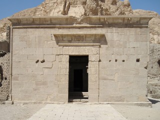 Temple of Hathor at Deir el-Medina on Luxor’s West Bank, where Coptic graffiti document later Christian use of the site.
Image Credit:
Olaf Tausch, CC BY 3.0, via Wikimedia Commons
Mapping Monastic Egypt: Digital Archaeology Reveals Coptic Networks Across the Nile and Desert
A new archaeological research project is using digital mapping, field survey and network analysis to reconstruct how Christian monastic communities were connected across Egypt during Late Antiquity. By combining archaeological remains, inscriptions, ancient transport routes and documentary evidence, the work aims to move beyond studying monasteries as isolated religious sites and instead examine how they functioned within wider systems of mobility, communication and exchange between the third and seventh centuries AD.
A major case study focuses on the West Bank of Luxor, where desert landscapes preserve extensive traces of Christian occupation alongside older Pharaonic and Greco-Roman remains. Fieldwork carried out in 2020 documented more than 1,517 Coptic graffiti and inscriptions and 163 Christian structures, including churches, monasteries and hermitages. These remains provide a dense archaeological record for examining how Christian communities occupied and transformed a landscape positioned between the desert escarpment and the cultivated Nile floodplain.
The study area covers about 100 square kilometres. Archaeologists systematically recorded religious buildings, ancient pathways and surface artefact scatters, while georeferencing features under consistent survey conditions. The resulting spatial database brings together information on chronology, building type, preservation and archaeological context. It also incorporates historical transport infrastructure, including roads, tracks, river routes and other communication corridors identified through fieldwork, maps and remote-sensing evidence.
This integrated approach allows researchers to analyse how settlement patterns were related to movement. Geographic information systems and network models are being used to estimate travel times, transport costs and likely routes between sites. Rather than assuming that monasteries were remote or economically isolated, the models can test how easily communities could reach cities, river crossings, roads and neighbouring settlements.
The results underline the importance of both the Nile and overland routes. The reconstructed network combines terrestrial corridors with river transport and ports, allowing researchers to examine mobility across a landscape in which movement by land and water was closely intertwined. Connectivity varied significantly across Egypt, with some areas positioned much more favourably than others within the transport system. In the Thebaid, the analysis shows clusters of Christian settlements linked by major and secondary routes, while Roman-period cities are mapped as important reference points within the wider landscape. The models suggest that monastic communities were embedded in regional networks rather than simply scattered across marginal desert zones.
Luxor’s West Bank is particularly revealing because its abandoned ancient settlements and preserved tracks are often missing from modern topographic maps. Reconstructing these routes makes it possible to explore how Late Antique inhabitants moved through a landscape already shaped by centuries of earlier occupation. Christian sites can therefore be examined not only in relation to sacred spaces, but also to inherited transport corridors and economic connections.
The project also highlights the value of graffiti and inscriptions as evidence for activity and movement. Their distribution can help identify zones of repeated presence and connect religious activity with specific buildings, paths and areas of occupation. At Deir el-Medina, Coptic graffiti survive on earlier temple walls, while at Medinet Habu Christian structures were established within the monumental complex of the Temple of Ramesses III. These examples illustrate how Christian communities reused older sacred and urban landscapes rather than developing entirely separate environments.
A further goal is to make the project’s data openly accessible. A public online platform planned for early 2027 is intended to allow users to explore maps, examine records of Christian buildings and work directly with geospatial datasets. The platform will also support the creation of historical maps and other visualisations.
By linking monasteries, churches, inscriptions, roads and river routes within a single analytical framework, the project is offering a broader view of Coptic Egypt. The emerging picture is one of religious communities deeply connected to mobility, settlement and exchange, revealing monastic landscapes as active parts of Late Antique Egypt’s social and economic geography.
Published on: 17-09-2026
Edited by: Abdulmnam Samakie
Source: Antiquity