- Archaeological News
-
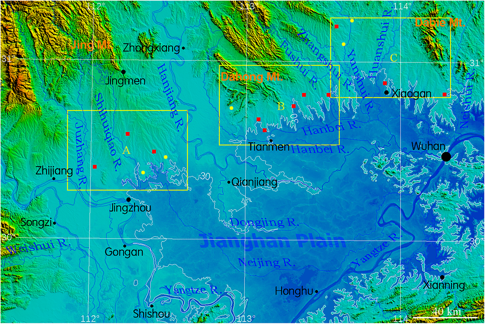
 Topographic map of the northern Jianghan Plain in Hubei Province, showing the main foothill zones, rivers, and prehistoric settlement areas examined in the study.
Image Credit:
Jianguo Liu, Humanities and Social Sciences Communications (2026)
Ancient “City Walls” in China May Have Been Hydraulic Systems for Rice Farming
Prehistoric communities in the northern Jianghan Plain of central China may have engineered their settlements around water management rather than defense, according to a new study that reexamines a series of walls, ditches, pools and dams traditionally associated with fortified settlements. Using drone-based terrain models, satellite imagery, archaeological evidence and hydrological simulations, the research argues that many of these structures were designed primarily to control floods and provide water for rice fields during dry periods.
The Jianghan Plain lies along the middle reaches of the Yangtze River in Hubei Province, where low mountains and foothills descend toward a broad landscape of rivers, lakes and wetlands. Its warm monsoon climate creates unusually favorable conditions for rice cultivation, but it also produces a difficult seasonal cycle: heavy rainfall can cause flooding in early summer, while midsummer and autumn frequently bring drought. Prehistoric farming communities therefore faced the challenge of dealing with both too much and too little water within the same agricultural year.
The region contains settlements associated with cultures including Bianfan, Youziling, Qujialing and Shijiahe, spanning roughly 6900 to 4000 years ago. Archaeologists have long identified some of the large embankments surrounding these settlements as city walls, often linking their appearance to growing social complexity. Yet several features do not resemble conventional defensive architecture. At Shijiahe, for example, part of the exterior slope is only about 25 degrees, raising questions about its effectiveness as a fortification.
To reconsider their function, the study used drone photography to produce high-resolution digital surface models of prehistoric sites. These models were combined with older satellite images, regional elevation data, excavation reports, field investigation, drilling and computer simulations of how water would have moved and accumulated around the settlements. This allowed the researcher to examine the relationship between walls, ditches, natural valleys, rivers and nearby farmland at a landscape scale.
Several sites reveal systems that appear closely connected with agriculture. At Yinxiangcheng, a low-lying area beside the settlement contained high concentrations of rice pollen, while the surrounding embankment and ditch could have helped regulate water. At Majiayuan, openings in the western wall appear to have allowed water to be diverted into the settlement. Nearby Jingjiacheng was located on a naturally elevated platform, while an excavated area beside it formed a pool capable of storing rainwater during wet months and supplying fields during the dry season.
Chenghe presents an even more elaborate example. Digital terrain analysis indicates inner and outer ditches, embankments, drainage features and prehistoric dams that redirected water from nearby valleys. According to the study, these structures could protect the settlement from seasonal flooding while simultaneously channeling water into low-lying land suitable for rice cultivation. As the settlement expanded, the hydraulic system appears to have grown with it, incorporating a larger portion of the surrounding valley.
Evidence from Qujialing points to water management on an even larger scale. Archaeological work has identified dams, floodways and water-storage areas dating to approximately 5100–4900 years ago. Hydrological simulations suggest that each of two major dams controlled a catchment of nearly five square kilometres, potentially storing substantial quantities of rainy-season water for later irrigation.
At Shijiahe, communities faced a different problem. Settlements situated above the flood-prone lowlands were relatively safe from inundation but had more difficulty obtaining water for crops during dry periods. Early solutions included pools dug at the upper ends of small valleys. Later, larger dams and a diversion canal about 1.8 kilometres long were constructed to bring water from the East River toward agricultural areas that could not be irrigated directly from the lower river valleys.
The study therefore proposes that many of the so-called “walls” around low-lying prehistoric settlements functioned much like dikes or embankments, while communities on higher terrain invested instead in reservoirs, pools and diversion channels. In this interpretation, settlement design was closely adapted to local topography: flood-prone places needed protection from excess water, while elevated areas required systems capable of storing and delivering it.
These developments appear to have intensified around 5,000 years ago, when large-scale water-management facilities accompanied the growth of major settlements such as Qujialing, Shijiahe and Chenghe. The study links improved water control with the expansion of rice cultivation, rising food production and increasingly complex communities. More broadly, the findings suggest that some of the monumental earthworks of prehistoric central China may be understood not simply as defensive architecture, but as parts of extensive agricultural landscapes engineered to survive alternating floods and droughts.
Published on: 01-10-2026
Edited by: Abdulmnam Samakie